📑 Table of Contents
Continental Drift and Plate Tectonics
Section 1: The Quest to Understand Earth's Dynamic Nature
1.1 Introduction: The Concept of a Dynamic Earth vs. a Static Earth
The evolution of geomorphology and earth sciences represents a profound intellectual transition from the paradigm of a static Earth to the realization of a deeply dynamic planetary system. For centuries, the prevailing consensus among the scientific community was grounded in "fixism"—the belief that the Earth’s major topographic features, including continental masses and deep ocean basins, were permanent, immovable fixtures formed during the planet's primordial cooling phase. Within this static framework, geological features such as mountain ranges were attributed to localized catastrophic events or the gradual shrinking of the Earth's crust as it cooled, much like the wrinkling skin of a drying apple.However, as global cartography became increasingly precise and geological observations expanded across different continents, this static model began to fracture under the weight of irreconcilable anomalies. The transition to a "mobilist" paradigm—the understanding that the Earth’s outer shell undergoes continuous, large-scale lateral deformation—fundamentally rewrote the laws of physical geography. This shift recognized that the planetary surface is governed by immense internal thermal engines, constantly destroying and recreating the lithosphere in a relentless cycle of tectonic activity.
1.2 Early Observations: Cartographic Curiosities and Fossil Anomalies
The earliest inklings of a dynamic Earth did not originate from geologists, but rather from the keen eyes of mapmakers. As early as the 11th century, the Persian polymath Abū Rayhān Bīrūnī observed the geology of the Indian subcontinent and deduced that it was once a sea that had later become land, attributing this to the drifting of alluvium. However, the most striking cartographic anomaly was the geometric congruence of the Atlantic coastlines. In 1596, the Flemish cartographer Abraham Ortelius, in his seminal work Thesaurus Geographicus, explicitly noted the striking symmetrical fit of the Americas with Europe and Africa. Ortelius hypothesized that the Americas had been "torn away from Europe and Africa... by earthquakes and floods," marking the first recorded proposition of continental displacement. He urged observers to bring forward a map of the world and consider carefully the coasts of the three continents to see the vestiges of this planetary rupture.This cartographic puzzle was subsequently noted by intellectual heavyweights such as Francis Bacon in 1620 and Benjamin Franklin, but it remained a geographical curiosity until the mid-19th century. In 1858, the French geographer Antonio Snider-Pellegrini advanced the concept significantly by publishing two maps illustrating how the American and African continents might have once formed a single landmass before separating. Snider-Pellegrini's critical contribution was the integration of paleontological evidence; he observed that identical fossilized terrestrial plants were located in coal deposits on both sides of the vast Atlantic Ocean. Although his proposed mechanism—the biblical Great Flood—lacked scientific validity, his methodological synthesis of shape-matching and fossil correlation laid the foundational bedrock for all future tectonic theories.
1.3 Setting the Stage for a Scientific Revolution
By the late 19th and early 20th centuries, geologists faced a mounting crisis. They were struggling to explain the global distribution of identical geological formations, paleoclimatic records, and biological species separated by impassable oceanic expanses. To preserve the static Earth model, the scientific establishment concocted elaborate "land bridge" theories. They hypothesized the existence of sunken continents—such as the hypothetical "Lemuria" proposed to connect India, Madagascar, and Africa—to explain the distribution of specific flora and fauna.However, the principles of isostasy eventually rendered these explanations geophysically impossible. Lighter continental crust (sial) could not simply sink into the much denser oceanic crust (sima) without violating fundamental physical laws. The stage was irrevocably set for a comprehensive scientific framework that could harmonize the empirical observation that continents and oceans have not always occupied their present geographic coordinates.
Section 2: Continental Drift Theory (Alfred Wegener, 1912)
2.1 Core Postulates
The disparate strands of cartographic, geological, and paleontological anomalies were masterfully synthesized into a coherent scientific hypothesis by the German meteorologist and geophysicist Alfred Wegener. In 1912, Wegener systematically articulated the Continental Drift Theory, which he later expanded into his magnum opus, Die Entstehung der Kontinente und Ozeane (The Origin of Continents and Oceans), published in 1915.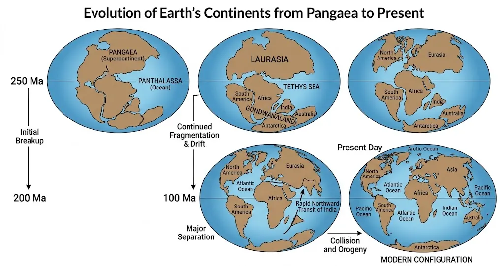
According to Wegener's model, the supercontinent cycle reached a critical juncture around 200 million years ago when Pangaea began to fracture and drift apart. The initial continental rifting split Pangaea along an east-west axis, creating two massive sub-continents: Laurasia in the northern hemisphere (comprising modern-day North America, Europe, and Asia) and Gondwanaland in the southern hemisphere (comprising South America, Africa, Peninsular India, Antarctica, and Australia). The massive void created by this initial equatorial separation was inundated by the waters of Panthalassa, forming a shallow, warm equatorial marine body known as the Tethys Sea. Over subsequent geological epochs, Laurasia and Gondwanaland continued to fragment and drift, eventually assuming the current configuration of the global map.
2.2 Compelling Evidences for Continental Drift
Wegener’s hypothesis was revolutionary because it relied on an exhaustively researched, multidisciplinary evidentiary base. For civil services aspirants, understanding the depth of this evidence is paramount for analytical reasoning in the Mains examination.- The Matching of Continents (The "Jig-Saw-Fit"): The most visually intuitive evidence remains the remarkable geometric congruence of opposing continental coastlines, most notably the eastern margin of South America and the western margin of Africa. Critics initially argued that coastal erosion would alter shorelines over millions of years, invalidating the fit. However, when modern geologists matched the continents at the 1,000-fathom depth contour (the true edge of the continental shelf, submerged far below the erosional forces of waves), the mathematical fit was virtually perfect, negating the statistical possibility of mere coincidence.
- Rocks of the Same Age Across Oceans: Radiometric dating techniques provided undeniable geochemical proof. A continuous, distinct belt of ancient Precambrian rocks, dated to approximately 2,000 million years old, spans the coast of Brazil and perfectly aligns with a similarly aged, geochemically identical rock belt in West Africa. The stratigraphy of these sequences dictates that they were formed as a single, contiguous geological formation before being tectonically sheared apart.
- Tillite Deposits (Paleoclimatic Evidence): Tillite is a highly distinctive sedimentary rock formed by the lithification of glacial till—the unsorted rock debris deposited directly by massive ice sheets. Extensive tillite deposits belonging to the Gondwana system are found seamlessly across India, Africa, Madagascar, Antarctica, and Australia. The presence of deep glacial striations and tillite in regions like Peninsular India and Central Africa, which currently experience extreme tropical climates, proves definitively that these landmasses were once clustered together near the South Pole and shared a uniform, frigid paleoclimate prior to their northward drift.
- Placer Deposits: The occurrence of highly concentrated placer gold deposits along the coast of Ghana in West Africa presented a severe geological anomaly, as the region completely lacks the primary gold-bearing source veins. Conversely, the exact mineralogical source veins for this specific gold are located directly across the Atlantic Ocean in the Brazilian plateau. This geospatial separation implies that the Ghanaian gold was deposited by rivers eroding the Brazilian highlands when the two continents were physically conjoined.
- Distribution of Fossils: The paleontological record reveals terrestrial flora and fauna separated by vast, uncrossable oceanic barriers. Fossils of the Mesosaurus, a small freshwater reptile entirely incapable of swimming across an ocean, are found exclusively in highly specific Permian strata in South America and South Africa. Similarly, the fossilized remains of the Glossopteris fern are documented extensively across India, Australia, Antarctica, and Africa. Furthermore, the observation that identical Lemur fossils occur in India, Madagascar, and Africa led to the obsolete "Lemuria" land-bridge hypothesis, which Wegener elegantly replaced with his unified drifting continents model.
2.3 Proposed Driving Forces (Wegener's Weakness)
Despite the overwhelming empirical and observational evidence, Wegener’s theory contained a fatal flaw: he struggled to identify a geophysically plausible mechanism powerful enough to overcome the massive friction of continental movement. He proposed two primary forces to explain the drift:- The Pole-fleeing Force (Polflucht): Wegener attributed the general equator-ward movement of the continental masses to the centrifugal force generated by the Earth's axial rotation. He argued that this rotational force, which creates the planet's equatorial bulge, pushed landmasses away from the poles.
- Tidal Force: To explain the westward drift of the Americas away from Europe and Africa, Wegener suggested that the gravitational attraction of the Sun and Moon, which creates oceanic tides, acted as a constant frictional drag on the solid continents, slowly retarding their rotation and pulling them westward relative to the underlying mantle.
2.4 Criticism and Rejection by the Scientific Community
The scientific community, dominated by established "fixist" geologists and rigorous geophysicists, overwhelmingly rejected Wegener's hypothesis upon its publication. The rejection was not based on his observational data—which was robust—but entirely on the inadequacy of his proposed physical mechanisms.Prominent physicists demonstrated mathematically that the centrifugal and tidal forces proposed by Wegener were infinitesimal—millions of times too weak to propel rigid, granitic continental rock through the highly dense, basaltic ocean floor. Geophysicists argued that if tidal forces were actually strong enough to move continental masses, the resulting frictional dissipation would halt the Earth's rotation entirely within a span of a few years. Because he could not provide a viable "engine" for the drift, Wegener's groundbreaking theory was largely marginalized, and he died in 1930 on an expedition in Greenland without seeing his life's work vindicated.
Section 3: Post-Drift Discoveries - The Bridge to Plate Tectonics
The rehabilitation of continental drift required a fundamental pivot in geological exploration. Instead of merely observing the exposed continental crust, scientists needed to probe the deep interior of the Earth and map the dark, unexplored abysses of the ocean floors.3.1 Convectional Current Theory (Arthur Holmes, 1928-1930s)
In the late 1920s and 1930s, the British geologist Arthur Holmes provided the critical missing link by proposing a geophysically plausible driving force. Following the relatively recent discovery of radioactivity, Holmes hypothesized that the spontaneous decay of radioactive elements (such as uranium, thorium, and potassium) within the Earth's mantle generated immense, localized primordial heat.This extreme thermal disparity creates vast convection currents within the solid, yet highly ductile, substratum of the mantle. Much like boiling water circulating in a pot, intensely hot, less dense mantle material rises toward the crust, spreads laterally, and then progressively cools and sinks back into the profound depths. Holmes proposed that the continents essentially "rode" on the backs of these sluggishly moving convective cells. This fundamentally shifted the paradigm: continents were not actively plowing through the solid ocean floor as Wegener had imagined; instead, they were passively transported with the moving lithosphere, driven by deep mantle convection.
3.2 Mapping of the Ocean Floor (Post-WWII)
Following World War II, the deployment of advanced sonar, echo-sounding technology, and extensive bathymetric surveys revolutionized oceanography. Contrary to the long-held belief that the ocean floor was a flat, featureless abyssal plain, the marine topography was revealed to be highly rugged, dynamic, and structurally complex.Researchers discovered an interconnected, global underwater mountain chain—the Mid-Oceanic Ridges (MORs)—stretching over 65,000 kilometers beneath the sea, characterized by high thermal activity and central rift valleys. Furthermore, incredibly deep, arcuate depressions known as oceanic trenches were mapped predominantly near continental margins and island arcs. Extensive rock sampling yielded a shocking realization: the oceanic crust is geologically very young, nowhere older than 200 million years (mid-Mesozoic), providing a stark contrast to continental cratons which harbor rocks dating back nearly 4 billion years. Additionally, the sediment layer on the ocean floor was unexpectedly thin, indicating that the ocean floor itself was not a permanent fixture collecting debris since the dawn of the planet.
3.3 Paleomagnetism and Magnetic Striping
The most definitive, incontrovertible proof of crustal movement emerged from the study of paleomagnetism. As basaltic magma rises at the Mid-Oceanic Ridges and cools below its Curie temperature, iron-rich minerals (like magnetite) align themselves with the prevailing orientation of the Earth's magnetic field, locking in a permanent magnetic signature.Because the Earth's magnetic poles periodically undergo geomagnetic reversals (where magnetic north becomes magnetic south), the cooling rock acts as a continuous tape recorder of Earth's magnetic history. Marine geophysical surveys revealed a remarkable and beautiful pattern: symmetrical, barcode-like stripes of alternating normal and reversed magnetic polarity running perfectly parallel to the crests of the Mid-Oceanic Ridges on both sides. This symmetrical striping proved unequivocally that the ocean floor was splitting and expanding continuously outward from the central ridges.
3.4 Seafloor Spreading (Harry Hess, 1961)
Synthesizing Holmes's mantle convection theory, the complex bathymetric data, and the irrefutable evidence of paleomagnetic striping, the American geologist Harry Hammond Hess proposed the transformative Seafloor Spreading Theory in 1961.Hess hypothesized that the intense heat from ascending mantle convection currents exerts severe tensional stress on the lithosphere, causing it to fracture precisely at the crests of the Mid-Oceanic Ridges. Mafic, basaltic magma continuously upwells through these fractures, cools upon contact with the frigid ocean water, and forms entirely new oceanic crust. As more magma relentlessly rises, it acts as a wedge, constantly pushing the older, previously formed seafloor outward and laterally away from the ridge crest in both directions. This explained why rocks equidistant from the MOR show exact similarities in age and composition, and why the age of the ocean floor progressively increases with distance from the ridge.
To explain why the Earth's total volume was not increasing despite this continuous creation of new crust, Hess brilliantly deduced the existence of subduction. He proposed that the older, colder, and highly dense oceanic crust is eventually dragged downward at the locations of descending mantle limbs—the deep oceanic trenches—where the massive ocean slabs are consumed and recycled back into the mantle. This elegant mechanism permanently solved Wegener's "driving force" problem, proving that ocean floors are dynamic, destructible, and recyclable conveyor belts that transport the continents across the globe.
Section 4: Plate Tectonics Theory - The Unifying Concept
4.1 Introduction
The profound insights of continental drift, mantle convection, and seafloor spreading ultimately converged into the grand, unifying scientific paradigm of Plate Tectonics. First comprehensively outlined in 1967 by a consortium of geophysicists including D.P. McKenzie, R.L. Parker, and W.J. Morgan, this theory systematically accounts for the macro-scale deformation of the Earth's surface. It serves as the foundational architecture for understanding the global distribution of seismicity, volcanism, orogenesis (mountain building), and the perpetual wandering of the continents.4.2 Understanding the "Plate": Lithosphere vs. Asthenosphere
To grasp the mechanics of plate tectonics, it is essential to distinguish between the Earth's compositional layers (crust, mantle, core) and its rheological, or mechanical, layers. A tectonic plate is defined exclusively by its mechanical properties.- The Lithosphere: This constitutes the outermost, rigid, and brittle shell of the Earth. The lithosphere is not synonymous with the crust; rather, it comprises the entire crust (both the lighter, granitic continental crust and the denser, basaltic oceanic crust) integrated tightly with the uppermost, solid structural portion of the mantle. The thickness of the lithosphere varies drastically, ranging from a mere 5 to 100 kilometers in oceanic regimes to massive depths of over 200 kilometers beneath ancient continental cratons. According to the theory, this brittle lithosphere is heavily fractured into distinct, massive slabs known as tectonic plates.
- The Asthenosphere: Situated immediately beneath the rigid lithosphere is the asthenosphere, representing the upper highly viscous region of the mantle. Due to the specific pressure-temperature regime at this depth, the rock exists in a ductile, semi-fluid, or plastic state. Because the asthenosphere possesses very low yield strength, it provides a lubricated layer upon which the rigid lithospheric plates can smoothly "float" and glide horizontally.
4.3 Major and Minor Plates
The global lithosphere is conventionally divided into seven primary tectonic plates and numerous secondary or minor plates. Understanding the precise geographical extent of these plates is a non-negotiable prerequisite for UPSC spatial analysis and map-based questions. A tectonic plate may be entirely oceanic or predominantly continental, but most major plates feature a combination of both.Table 1: The 7 Major Tectonic Plates
| Major Plate | Dominant Composition and Geographical Extent |
|---|---|
| Antarctic Plate | Encompasses the entire continent of Antarctica and extends outward to the surrounding Southern Ocean spreading ridges. |
| North American Plate | Comprises the North American continent and the western half of the Atlantic Ocean floor, extending to the Mid-Atlantic Ridge. |
| South American Plate | Comprises the South American continent and the western half of the South Atlantic Ocean floor, separating from North America along the Caribbean. |
| Pacific Plate | The largest tectonic plate; uniquely, it is almost entirely composed of dense oceanic lithosphere. |
| Indo-Australian Plate | A massive plate incorporating the Indian subcontinent, the Australian continent, New Zealand, and the intervening Indian Ocean floor. |
| African Plate | Encompasses the African continent and extends outward to the eastern floor of the Atlantic Ocean. |
| Eurasian Plate | Primarily a massive continental plate comprising Europe and Asia, extending into the adjacent oceanic regions. |
| Minor Plate | Exact Geographic Location |
|---|---|
| Cocos Plate | Situated beneath the Pacific Ocean, sandwiched between Central America and the massive Pacific plate. |
| Nazca Plate | Located in the eastern Pacific Ocean basin, actively subducting beneath the western coast of the South American plate. |
| Arabian Plate | Encompasses mostly the Saudi Arabian landmass and the surrounding coastal regions. |
| Philippine Plate | An oceanic plate located between the Asiatic continental margin and the Pacific plate. |
| Caroline Plate | Positioned in the western Pacific, bounded by the Philippine plate to the west and the Indian plate to the south (North of New Guinea). |
| Juan de Fuca Plate | A small, highly active remnant plate subducting under the Pacific Northwest of the North American Plate. |
| Scotia Plate | Located far south, sandwiched dynamically between the South American and Antarctic plates. |
4.4 The Mechanics of Movement
While Arthur Holmes correctly identified mantle convection as the primary source of thermal energy driving the system, modern geophysics recognizes two specific, gravity-driven kinematic forces that dictate the actual horizontal movement of the plates:- Slab Pull: This is currently recognized as the most potent driving force in plate tectonics. At convergent subduction zones, the aging oceanic lithosphere becomes extremely cold, dense, and thick. As it sinks into the highly pressurized mantle, metamorphic phase changes (such as the transition from basalt to the much denser eclogite) cause the leading edge of the slab to become heavier than the surrounding asthenosphere. This dense sinking slab exerts a massive gravitational pull on the rest of the trailing tectonic plate, dragging it inexorably toward the trench.
- Ridge Push: At divergent boundaries along the Mid-Oceanic Ridges, the newly formed, exceptionally hot lithosphere sits at a significantly higher topographic elevation than the older, cooler, and denser abyssal plains. Gravity forces this elevated, buoyant crust to naturally slide downward and laterally away from the ridge crest, exerting a continuous "pushing" force that aids in plate separation.
Section 5: Plate Boundaries and Landforms
Plate boundaries represent the highly dynamic interfaces where tectonic plates interact. The specific nature of this interaction—whether plates pull apart, collide, or slide past one another—dictates the formation of the Earth's most dramatic geomorphological features, making this section highly critical for physical geography.5.1 Divergent Boundaries (Constructive Margins)
- Mechanism: At divergent boundaries, adjacent tectonic plates are subjected to extreme tensional stress, causing them to actively pull apart. As the rigid lithosphere thins and fractures, the decrease in confining pressure on the underlying asthenosphere triggers decompression melting. Massive quantities of basaltic magma upwell through the fissures to fill the expanding void, cooling to create entirely new oceanic lithosphere. Because planetary surface area is actively created here, these are defined as "constructive" margins.
- Landforms:
- Mid-Oceanic Ridges: When divergence occurs within a marine environment, it produces monumental, continuous underwater mountain chains, such as the Mid-Atlantic Ridge.
- Rift Valleys: When divergent tensional forces act upon a thick continental landmass, they initiate continental rifting. The continental crust fractures and drops downward along parallel normal faults, forming deep, linear grabens known as rift valleys. The Great East African Rift Valley is the premier modern geological laboratory for this process. If divergence continues, this continental rift will eventually drop below sea level, flooding to create a nascent ocean basin, exactly as the Red Sea was formed.
5.2 Convergent Boundaries (Destructive Margins)
At convergent boundaries, two plates are driven toward each other, resulting in immense compressional stress. Because older lithosphere must be consumed and recycled deep into the mantle to balance the creation of new crust at divergent zones, these are termed "destructive" margins. The resulting landforms are entirely contingent upon the specific densities of the colliding crustal types.Oceanic-Continental Convergence:
- Mechanism: When dense, heavy basaltic oceanic crust collides with highly buoyant, lighter granitic continental crust, the oceanic plate invariably yields, plunging downward into the mantle beneath the continental plate in a process known as subduction.
- Landforms: The initial down-warping of the subducting plate creates a profoundly deep, linear depression known as an Oceanic Trench (e.g., the Peru-Chile Trench) just off the continental coast. As the oceanic slab descends into higher temperature and pressure zones, hydrous minerals within the rock dehydrate, releasing massive volumes of water. This water infiltrates the overriding wedge of mantle rock, drastically lowering its melting point and triggering widespread flux melting. The highly volatile, silica-rich magma ascents forcefully through the continental crust, erupting to form massive coastal Volcanic Mountain Ranges (e.g., the Andes, the Rocky Mountains).
- Mechanism: When two distinct oceanic plates converge, the older, colder, and therefore relatively denser plate undergoes subduction beneath the younger, more buoyant plate.
- Landforms: This ferocious convergence creates the deepest topographical features on Earth, such as the Mariana Trench. Similar to oceanic-continental subduction, flux melting generates ascending plumes of magma. Over millions of years, repetitive submarine eruptions build massive volcanic edifices that eventually breach the ocean surface, forming an arcuate chain of highly active volcanic islands known as a Volcanic Island Arc (e.g., the Japanese Archipelago, the Philippine Archipelago, and the Indonesian Archipelago).
- Mechanism: When two massive, highly buoyant, low-density continental plates collide, subduction grinds to a halt. The low-density granitic crust is simply too light to be forced down into the ultra-dense mantle. Consequently, the immense, unrelenting compressional forces cause the crust to buckle, shorten, highly fold, and extensively thrust-fault upon itself.
- Landforms: This process orchestrates the highest topographic elevations on the planet, creating massive, sprawling Fold Mountains characterized by extensive high-altitude plateaus and intense, shallow seismicity, but a conspicuous lack of volcanic activity (e.g., the Himalayas, the Alps).
- Ophiolite Suites: A hallmark geomorphological feature of this profound convergence is the obduction (the extreme upward thrusting) of fragmented remnants of the former oceanic crust and upper mantle onto the margins of the colliding continents. These displaced, highly deformed rock sequences—comprising deep-sea cherts, pillow basalts, sheeted dykes, and ultramafic mantle rocks—are known as Ophiolites. Found spectacularly high in mountain belts, such as within the Indus-Yarlung Tsangpo Suture Zone in the Himalayas, ophiolite suites serve as the ultimate, incontrovertible "fossil evidence" documenting that a vast, ancient ocean basin (the Neo-Tethys) once existed between the continents before being entirely consumed by subduction.
5.3 Transform Boundaries (Conservative Margins)
- Mechanism: At transform boundaries, tectonic plates slide laterally past one another in a purely horizontal motion along massive, vertical fracture zones. Because lithosphere is neither constructively created nor destructively consumed, these are classified as "conservative" margins.
- Landforms: While they do not produce the striking, vertical topographic features associated with other boundaries—such as towering volcanoes or abyssal trenches—they are defined by highly visible, massive linear fault lines. The continuous, grinding friction between the passing plates frequently locks them together, accumulating immense strain over centuries that is violently released in highly destructive, shallow-focus earthquakes. The San Andreas Fault in California, accommodating the dextral sliding of the Pacific plate past the North American plate, stands as the most famous terrestrial example of a transform boundary.
| Boundary Type | Dominant Stress | Primary Tectonic Activity | Key Landforms Created | Classic Geographic Examples |
|---|---|---|---|---|
| Divergent | Tensional | Crustal creation, shallow earthquakes, effusive volcanism. | Rift Valleys, Mid-Oceanic Ridges | Great East African Rift, Mid-Atlantic Ridge |
| Convergent | Compressional | Crustal destruction, deep-focus earthquakes, explosive volcanism (except C-C). | Deep-sea Trenches, Volcanic Island Arcs, Fold Mountains | Himalayas (C-C), Andes (O-C), Japan (O-O) |
| Transform | Shear | No crustal creation/destruction, severe high-magnitude seismicity, absent volcanism. | Strike-slip fault lines, linear offset streams | San Andreas Fault, North Anatolian Fault |
Section 6: The Journey of the Indian Plate
The tectonic evolution and chronological migration of the Indian Plate constitutes a foundational chapter in Indian physical geography. It represents one of the most dramatic, rapid, and geologically consequential continental migrations recorded in Earth's history.6.1 Breakup from Gondwanaland and Rapid Transit
Approximately 200 to 225 million years ago, during the fragmentation of the Pangaean supercontinent, the Indian landmass was positioned deep in the Southern Hemisphere, attached to Madagascar and Australia as an integral part of the southern Gondwana block. Around 130 to 140 million years ago, the subcontinent, situated roughly at 50° S latitude, firmly severed its connections to Gondwanaland and commenced its solitary, relentless northward journey toward the Eurasian landmass.This transit was not just notable for its distance, but for its unprecedented speed. While conventional tectonic plates drift at a leisurely pace of 2 to 5 centimeters per year, paleomagnetic tracking reveals that around 80 million years ago, the Indian Plate suddenly accelerated to a staggering velocity of 15 to 20 centimeters per year. Advanced numerical models and structural geology suggest this hyper-velocity was driven by a highly complex double subduction system. Within the vast Neo-Tethys ocean, two parallel subduction zones operated simultaneously, with two massive oceanic slabs diving beneath Eurasia. This dual-subduction architecture effectively doubled the "slab pull" gravitational force acting upon the connected Indian landmass, slingshotting it northward across the equator.
During its high-speed transit over the nascent Indian Ocean approximately 60 to 65 million years ago, the Indian Plate passed directly over the Reunion Hotspot—an extraordinarily powerful, stationary plume of superheated mantle material upwelling from near the Earth's core. The intense thermal anomaly pierced the migrating Indian lithosphere, triggering millions of years of massive, effusive fissure volcanism. These colossal outpourings of low-viscosity flood basalts layered upon each other to create the Deccan Traps, which currently define the rugged, stair-step plateau topography of Peninsular India.
6.2 The Collision and Closing of the Tethys Sea
As India surged northward, the vast expanse of dense, basaltic oceanic crust belonging to the Neo-Tethys Sea—which separated the Indian subcontinent from the Eurasian Plate—was continuously and relentlessly subducted beneath the southern margin of the Tibetan block.The total consumption of this intervening oceanic crust culminated in a catastrophic "hard collision" between the leading edge of the continental crust of India and the continental margin of Eurasia approximately 40 to 50 million years ago, during the Eocene epoch. As the two massive continental blocks collided, the shallow Tethys Sea was squeezed out of existence, closing forever and forcefully trapping its immense, accumulated layers of marine sediments and limestone between the colliding geological titans.
6.3 The Aftermath: The Himalayas and Seismicity
Because both the Indian and Eurasian plates are composed of low-density, highly buoyant granitic rocks, full subduction ceased entirely. Instead, the unabated, immense compressional forces caused the crust of both plates to violently deform, telescope, and thrust upward, orchestrating the rapid orogenic uplift of the Himalayas and the vast elevation of the Tibetan Plateau. The Indian Plate continues to drive deeply into the Eurasian block at a relative rate of 40–50 millimeters per year, ensuring that the Himalayas remain a geologically youthful, actively rising mountain range.Why the Himalayas are highly prone to earthquakes but lack volcanoes: This dichotomy is a critical analytical point for civil services aspirants. The Himalayan arc is classified among the most seismically volatile zones globally (encompassing Seismic Zones IV and V in India). This intense seismicity is the direct consequence of the ongoing continental collision; the relentless northward push of the Indian Plate generates extreme frictional stress along major fault lines (such as the Main Central Thrust and Main Boundary Fault). When this accumulated elastic strain exceeds the rock's structural threshold, it is violently released as highly destructive, shallow-focus earthquakes.
Conversely, the Himalayas lack active volcanoes entirely. Volcanism at convergent boundaries relies fundamentally on the subduction of a hydrated oceanic plate to induce flux melting in the overlying mantle wedge. In the Himalayan collision zone, the oceanic crust of the Tethys has been completely consumed and destroyed. The current convergence is strictly continent-to-continent. The immense compressive forces have effectively doubled the thickness of the continental crust (reaching profound depths of up to 70-80 kilometers beneath the Tibetan Plateau). This massive, ultra-thick sequence of low-density crust acts as an impenetrable barrier; even if minor localized melting occurs deep within the crust, the granitic magma lacks the requisite pressure, volatility, and thermal energy to pierce such a massive continental shield, resulting instead in vast underground granite batholiths that only become visible after millions of years of surface erosion.
Section 7: Geomorphological and Economic Significance
The theoretical mastery of plate tectonics transcends abstract geology; it serves as the ultimate explanatory key to understanding the global distribution of catastrophic natural hazards, the strategic locations of critical economic resources, and the profound drivers of long-term global climate change.7.1 Global Distribution of Hazards
The rigid boundaries of tectonic plates perfectly map the spatial distribution of the planet's most devastating natural hazards:- The Pacific Ring of Fire: This nearly continuous, horseshoe-shaped chain of deep-sea trenches and explosive volcanic arcs circumscribing the Pacific Ocean accounts for an astounding 75% of the world's active volcanoes and 90% of global earthquakes. It perfectly aligns with the massive subduction zones where the expanding Pacific plate is being violently thrust beneath surrounding continental and minor plates.
- The Alpine-Himalayan Seismic Belt: This highly active orogenic and seismic belt, stretching from the Mediterranean Sea through the Middle East to the Himalayas, directly traces the exact, ongoing continental collision boundary where the northward-moving African, Arabian, and Indian plates are aggressively ramming into the massive Eurasian plate.
- Mid-Atlantic Ridge Volcanism: Divergent boundaries host continuous fissure eruptions and effusive volcanism. This is most spectacularly visible in Iceland, a landmass situated directly atop the divergent Mid-Atlantic Ridge and coincidentally over an active mantle hotspot, leading to constant crustal expansion and geothermal activity.
7.2 Resource Distribution
The paleogeographic movement and historical interaction of tectonic plates fundamentally dictate the modern economic geography of natural resources, a critical topic for geospatial resource analysis.- Metallic Minerals: The formation of economically indispensable metallic minerals like copper, zinc, gold, and uranium is intrinsically linked to hydrothermal and magmatic activities at specific plate boundaries. For instance, the exceptionally rich porphyry copper deposits of the Andes Mountains were formed by mineral-laden hydrothermal fluids ascending from the deeply subducting Nazca plate beneath South America.
- Fossil Fuels: The global distribution of hydrocarbons is profoundly influenced by tectonic history. The immense, strategic oil and natural gas reserves of the Middle East (e.g., within the Zagros Mountains region) are the direct consequence of the slow tectonic closure of the shallow, nutrient-rich Tethys Sea. Over millions of years, vast quantities of marine organic matter accumulated, were buried, and subsequently "cooked" by geothermal heat into hydrocarbons, which eventually became perfectly trapped in the heavily folded anticlines created by the ongoing tectonic collision between the Arabian and Eurasian plates.
- Coal in Antarctica: The presence of extensive, high-quality coal seams buried deep beneath the freezing, barren ice sheets of Antarctica stands as a stark anomaly. Because coal can only form from the massive accumulation of lush, tropical forest vegetation, its presence definitively proves that Antarctica once occupied a geographic location near the warm equator as part of Gondwanaland, before tectonically drifting southward to freeze at the pole.
7.3 Climate Influence
Plate tectonics functions as the ultimate, long-term thermostat for global climate variations by altering continental configurations, which in turn radically alters global ocean circulation and atmospheric currents.- The Icehouse Transition (Drake Passage): Approximately 35 to 40 million years ago, the tectonic separation of the South American continent from the Antarctic Peninsula opened a deep oceanic gateway known as the Drake Passage. This tectonic rupture allowed the unfettered formation of the fierce Antarctic Circumpolar Current. This massive ocean current effectively isolated Antarctica oceanographically, completely severing it from warm, equatorial ocean currents and plunging the southern continent into permanent, deep glaciation, shifting the entire planet toward an "icehouse" climate.
- The Isthmus of Panama: Around 3 to 5 million years ago, active tectonic uplift combined with volcanic island arc formation closed the deep seaway that once existed between North and South America, creating the Isthmus of Panama. This critical tectonic event severed the equatorial mixing of the Atlantic and Pacific oceans. Consequently, warm, highly saline equatorial waters were violently redirected northward to form the powerful Gulf Stream. The massive influx of moisture into the high northern latitudes precipitated as heavy snow, triggering the vast continental glaciations of the modern Northern Hemisphere Ice Ages.
- The Asian Monsoon System: The relentless tectonic uplift of the immense Himalayas and the vast, elevated Tibetan Plateau erected an unprecedented orographic barrier in the Northern Hemisphere. This massive topographic wall radically altered atmospheric circulation patterns, intensifying the thermal low-pressure systems in summer and blocking cold northern winds in winter, ultimately establishing and anchoring the highly complex modern South Asian Monsoon system. Furthermore, the rapid erosion of these newly uplifted silicate rocks pulled massive amounts of carbon dioxide out of the atmosphere via chemical weathering, contributing significantly to global cooling trends over the past 50 million years.
Section 8: UPSC Exam Strategy & Quick Revision
For civil services aspirants, mastering the intricacies of Plate Tectonics requires a sophisticated blend of profound conceptual clarity for the Mains examination and exact factual precision for the Prelims.8.1 Fact-Sheet and Mnemonics for Prelims
Map-based questions frequently test the spatial recognition of minor tectonic plates and their interactions with major plates. Utilizing strategic memory aids ensures high retention.Crucial Minor Plates Location Guide:A high-yield area for Prelims involves matching minor plates to their geographical borders.
Table 4: Minor Plate Geographic Matching
| Minor Plate | Precise Geographical Location for Map Work |
|---|---|
| Cocos Plate | Sandwiched between Central America and the massive Pacific Plate. |
| Nazca Plate | Located between the western coast of South America and the Pacific Plate. |
| Arabian Plate | Encompasses mostly the Saudi Arabian landmass. |
| Philippine Plate | An oceanic plate positioned between the Asiatic continent and the Pacific Plate. |
| Juan de Fuca Plate | Situated southeast of the North American Plate, specifically near the USA Pacific Northwest coastline. |
| Caroline Plate | Located north of New Guinea, wedged between the Philippine and Indian plates. |
| Scotia Plate | Located in the far south Atlantic, between the South American and Antarctic plates. |
8.2 PYQ Analysis and Framework Integration
UPSC Mains frequently deploys application-based questions that demand the integration of core physical geography concepts with dynamic, localized geomorphological phenomena.PYQ Case Study 1: "What do you understand by the theory of continental drift? Discuss the prominent evidences in its support." (UPSC Mains 2013)
- Framework Approach:
- Introduction: Concisely define the theory, attributing it to Alfred Wegener (1912). Introduce the foundational concepts of the supercontinent Pangaea and the mega-ocean Panthalassa, detailing their initial split into Laurasia and Gondwanaland during the Mesozoic era.
- Body (The Evidence): Do not merely list the points; rather, analytically explain why each point constitutes evidence.
- Discuss the Jig-saw fit utilizing the 1000-fathom contour for accuracy.
- Explain Tillite deposits as definitive proof of a shared, frigid paleoclimate near the South Pole.
- Detail Placer deposits by emphasizing the geographical separation of the gold sinks in Ghana from their primary source veins in Brazil.
- Mention the global distribution of identical fossils (Mesosaurus, Glossopteris) separated by impossible oceanic barriers, and support this with the Radiometric dating of ancient rock belts matching across the Atlantic.
- Conclusion: Conclude with a critical evaluation. State that while the observational evidence was flawless, the theory was temporarily rejected due to Wegener's reliance on incredibly weak driving forces (centrifugal and tidal). Note that it ultimately served as the indispensable stepping stone to the comprehensive theory of Plate Tectonics.
- Framework Approach: This question rigorously tests the understanding of Ocean-Ocean Convergent Boundaries and their resulting geomorphology.
- Introduction: Define an archipelago as an extensive, closely scattered group of islands. Contextualize their location by stating that both archipelagos sit directly on the highly volatile "Pacific Ring of Fire," a zone defined by intense tectonic convergence.
- Body - The Subduction Mechanism: Explain the specific, complex plate interactions driving the formation.
- The Indonesian archipelago is formed primarily by the aggressive subduction of the denser Indo-Australian Plate plunging beneath the Sunda Plate (a minor plate integrally attached to the Eurasian Plate), creating the deeply trenched Sunda/Java Trench system.
- The Philippines archipelago is similarly formed by the convergence of the massive Philippine Sea Plate and the Sunda/Eurasian Plate.
- Body - Volcanism and Uplift: Detail the subsequent magma genesis. As the subducting oceanic slabs descend, immense heat and pressure release volatiles (water), inducing flux melting in the overlying mantle wedge. This generates highly explosive magma that forcefully rises through the overriding oceanic crust, creating persistent submarine volcanoes. Over millions of years of sequential, violent eruptions, these volcanic peaks accumulate sufficient height to breach the ocean surface, forming extensive Volcanic Island Arcs.
- Conclusion: Add depth by mentioning supplementary factors like continuous sedimentation from rivers and altering sea levels during interglacial periods that assist in shaping the final, complex island topography. Conclude by emphasizing that this relentless tectonic collision makes the entire region acutely vulnerable to highly destructive earthquakes and devastating tsunamis.
8.3 Summary for Quick Revision
- Wegener’s Drift Theory: Proposed that continents float and drift; erroneously driven by pole-fleeing/tidal forces. Powerfully supported by the jigsaw fit of coastlines, matching fossil records, tillite paleoclimatology, and placer deposits.
- Arthur Holmes & Convection: Postulated that deep mantle convection currents, fueled by the intense heat of radioactive decay, provide the true thermodynamic engine of tectonic movement.
- Harry Hess & Seafloor Spreading: Proposed that the ocean floor acts as a conveyor belt; entirely new crust is constructively created at the Mid-Oceanic Ridges and older crust is destructively consumed at deep oceanic trenches.
- Plate Tectonics Unification: Rigid lithospheric plates effortlessly ride atop the plastic asthenosphere, kinematically driven by the massive gravitational forces of slab pull and ridge push.
- The Journey of the Indian Plate: Separated from Gondwana, achieved hyper-velocity due to a double subduction system, created the Deccan traps via the Reunion hotspot, and finally collided violently with Eurasia (closing the Neo-Tethys) to form the non-volcanic, highly seismically active Himalayas.
Authoritative References & Works Cited
Scientific & Geological Foundations- OpenGeology: Discovering plate tectonics – Historical Geology
- US Geological Survey (USGS): Historical perspective (This Dynamic Earth)
- Harvard University (Courses): Continental drift - Wikipedia, the free encyclopedia
- Massachusetts Institute of Technology (MIT News): India drift
- PubMed Central (NIH): The convergence history of India-Eurasia records multiple subduction dynamics processes
- UC Berkeley (Understanding Global Change): Plate Tectonics
- Elements Magazine: Ophiolites
- Polish Geological Journals: INDUS-TSANGPO SUTURE IN THE HIMALAYA: CRUSTAL EXPRESSION OF A PALAEO-SUBDUCTION ZONE
- Discover Magazine: Why Are Some Mountain Ranges Volcanic and Others Not?
- Traveling Geologist: Indus-Yarlung suture zone, southern Tibet - Douwe van Hinsbergen
- The University of Melbourne: How shifting tectonic plates drove Earth's climate swings
- Discovering Antarctica: Tectonic history: into the deep freeze
- Woods Hole Oceanographic Institution: Shifting Continents and Climates
- Eos.org: Three Times Tectonics Changed the Climate
- The University of Sydney: How plate tectonics have maintained Earth's 'Goldilocks' climate